Overview
Location
(County and State where the plantation/workspace was located. Information to help others locate the plantation is optional.)
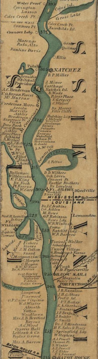
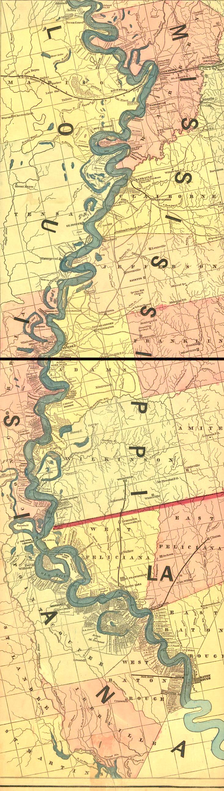
Concordia Parish, LA. (Known as St. John Parish during most of the plantation's existence). The plantation was on Maxwell Road. The only thing separating it from the MS River was Maxwell Road and the levee. The map coordinates for the plantation were T9N-R1E (Township 9 North, Range 1 East), in sections four through seven. Note that the details of many of the below maps w not exactly accurate or up-to-date when the maps were made.
- See the plantation listed by name on old maps at:
- See the plantation land on the original land survey at:
- See the plantation on a modern map at:
Date Constructed/ Founded
(Year the plantation/ workplace was established and/ or built.)
Probably prior to 1811.
- The plantation may have been started by Elijah Smith during the time that he was a business partner with Abijah Hunt (1800 - 1811). Abijah and Elijah had the firm of Hunt and Smith, which was a cotton brokerage that also ran five general stores and several public cotton gins. Elijah had married into the European nobility and was in Natchez investing his wife's fortune. Section 4 of the Hole in the Wall plantation may have just been a land investment for Elijah, or he may have been the one to develop it into a plantation.
- Abijah died in 1811. David Hunt inherited all of Abijah's land. Either David inherited the hole in the wall land from Abijah, or he bouht it from someone - probablly his Uncle Abijah's business partner Elijah Smith. More research into the land records is needed to see just how David Hunt acquired the land.
Associated Surnames
(List of surnames associated with this workplace.)
Hall, Hunt, Smith
Historical notes
(Historical summary of the workplace)
- General Information
- The plantation was between about 1,000 acres and 3,500 acres.
- The owners did not live on the plantation. Thus, thre was only a simple house for the manager and his family to live in.
- Cotton was the cash crop and corn would have been grown to feed the people and livestock. This was a very valuable plantation in the MS River Delta. It would have occasionally flooded, but this was good because it deposited rich silt onto the land keeping the soil highly productive year after year.
- The plantation had a MS River boat landing, known as Hole-in-the-Wall Landing, before the MS River caused too much land/islands, etc. to be built up on the river side of the levee in front of the plantation.
- After the Civil War, there was a Hole-in-the-Wall store where the share croppers could buy supplies.
- Hole-in-the-Wall Plantation is mentioned in Mark Twain's book Life on the Mississippi . It is mentioned because it marked an area of the MS River that had tricky river currents for boat captains to deal with.
- Photos
- Canebrake Plantation. Purely by chance, Canebrake has the only surviving complex of plantation sturctures in Concordia Parish and was just to the south of Hole-in-the-Wall on Maxwell Road. Cainbrake was very close to Hole-in-the-Wall but may not have adjoined it. Online photos of Canebrake give an excellent example of what Hole-in-the Wall (with no photos found so far) must have looked like. Links to photos and a description of Canebrake are at the bottom of the following webpage http://www.crt.state.la.us/hp/nationalregister/nhl/search_results.asp?search_type=parish&value=Concordia&pageno=1 .
- Buildings on similar plantations. Unlike on some of the Hunt clan's smaller plantations, big plantations like this one would have probably had their own cotton gin, press, and store.
- Description of the "Big House" on Hole-in-the-Wall Plantation. One of Elizabeth (Hunt) Ogden's (an owner of this plantation and daughter of David Hunt) grandaughters (Elizabeth Ogden Reed) wrote her recollection of what her mother, Estelle Ogden, told her about living on Hole-in-the-Wall. The quotes describe the plantation in the 1880s when Elizabeth (Hunt) Ogden's widower - William Frederick Ogden - and his second wife (Mary Davies) and children moved to the plantation to live.
- "Hole-in-the-Wall comprised 3,500 acres"
- "the house on the place was a story and a half cottage with two bedrooms in a wing. It was built for a manager and his family to live in and was very simple compared to the elegant home they left in New Orleans."
- "they fitted their furniture in as best they could and made the place quite comfortable and liveable."
- It was described "as having beautiful flowers and shrubs in the yard and the long front fence was covered with a running cherokee rose, beautiful in the spring and summer. The house was behind the levee but in those days the levees were not so high and boats going by could be seen and the passengers enjoyed the sight of all the flowers and especially the roses." This was probably in the spring when the MS River was high - possibly above the level of the plantation on the other side of the levee.
Associated Slave Workplaces
(Plantations/ workplaces connected to this one via owners' family and/ or enslaved persons.)
- Owners' Family Connections to Other Workplaces
- Before the Civil War
- During Elijah Smith's ownership (about 1800 to 1811) the plantation would have been associated with his other properties.
- During David and Ann Hunt's ownership (about 1811 - 1867) the plantation was associated with their other 24 plantations - see Woodlawn Plantation MS for the details of this.
- Enslaved Persons' Connections to Other Workspaces
- Ellen Hall of Hole-in-the-Wall Plantation met her husband, Jacob Stewart, while working on neighboring Canebrake Plantation . This information was submitted by Edward B Adams (Jacob Stewart was his great, great grandfather), and it originally came from the Civil War pension records of Jacob Stewart.
Associated Free Persons
(Bulletted list of free persons: plantation-owning family, overseers, etc. Example: "John Doe (b.1841-d.1885) - owner; inherited Doe Plantation from his father Joe Doe")
- Elijah Smith - owner. Elijah Smith was Abijah Hunt's partner in the business firm of Hunt and Smith. The firm was a cotton brokerage that also had five general stores and several public cotton gins. Smith was in Natchez investing his wife's fortune. Smith lived on the Windsor estate near Natchez, which was later absorbed into Haller Nutt's Longwood Estate. Smith may or may not have developed this land into a plantation.
- David Hunt (d. 1861) and his wife Ann Ferguson - absentee owners; They owned this plantation from about 1811 to about 1867. David Hunt came to MS from NJ in 1801 to work for his Uncle Abijah (a rich merchant and plantation owner) and to profit from slavery. He quickly started Woodlawn Plantation MS . Although he was doing well before his Uncle's death, after his Uncle's 1811 death he became seriously rich. His inheritance from his Uncle caused him to acquire several plantations. David may have gotten Hole in the Wall Plantation somehow from his Uncle's estate. David bought out Abijah's other partners (such as Elijah Smith) and heirs in the Hunt and Smith firm to get sole ownership of the firm. He may have bought Hole in the Wall at this time. His 1816 marriage to Ann Ferguson (a grandaughter of rich planter Robert Dunbar) caused him to acquire three or four more plantations. He eventually built up a plantation empire of 25 plantations with about 1,200 slaves and was one of only 35 millionaires in the U.S. at the time - possibly the 7th richest in the U.S. The David and Ann Hunt estate was divided in 1867. Hole in the Wall Plantation went to their daughter Elizabeth.
- Elizabeth (Hunt) and Cpt. William (Billy) Frederick Ogden, C.S.A. (Confererate States of America). Absentee owners after the Civil War who lived in the Garden Distirct (a fashionable suburb) of New Orleans. Inherited the plantation from David and Ann Hunt.
- Elizabeth Hunt was born to Ann and David Hunt on Woodlawn Plantation MS . She would have grown up with her family on Woodlawn in the winters and in Lexington, KY in the summers. She was educated at the Elizabeth Female Academy in Washington, MS - a few miles from Natchez. http://en.wikipedia.org/wiki/Elizabeth_Female_Academy . (The academy is supposed to have closed in 1843, so the family account is probably wrong that states that Elizabeth Hunt and her friend Eliza Ogden attended. Elizabeth was born around the 1843 closing time and married in 1865 - so her attendance seems impossible.)
- William (Billy) Frederick Ogden. He was the son of LA State Supreme Court Justice Abner Nash Ogden of New Orleans and Julia Smith Scott. Julia Smith Scott was the daughter of Dr. John T. Scott of Waverly Plantation on Second Creek south of Natchez (with only 7 slaves it was really just a farm - it took 20 slaves to reach plantation status). Her mother Nancy Ann Smith was the daughter of Israel Smith who owned Independence Plantation on Second Creek south of Natchez. William's mother, Julia Smith Scott died on Independence Plantation. William probably grew up at his parents home in Carrolton - a suburb of New Orleans http://www.crt.state.la.us/hp/nhl/search_results.asp?search_type=parish&value=Orleans&pageno=14 . He was educated at Oakland College in Claiborne County, MS http://claibornecountyms.org/oakland_college.htm probably because his mother would have known about it being from Nearby Natchez. He went home with Elizabeth Hunt's brothers on Christmas break from Oakland to nearby Woodlawn Plantation MS . There he met and fell in love with Elizabeth. William's sister Eliza attended the Elizabeth Female Academy where Elizabeth went to school as well. William graduated from Oakland College and then the University of Virginia Law School. Then he fought in the Civil War, was captured and held at Johnson's Island - a Prisoner of War camp in the north - http://www.johnsonsisland.org/ . He caught typhoid in the camp and returned in a weakened condition.
- William regained his health and married Elizabeth in 1865. William was a lawyer as was his father and his two brothers. William's brother Horatio was the LA State Attorney General and lived in New Orleans. His other lawyer brother lived in Rapides Parish, LA. He also had a sister Eliza who never married. William and Elizabeth lived in a large house on a corner of Jackson and Caroundelet Streets in the Garden District of New Orleans after their marriage (The following link has information and photos of houses in the Garden District at the bottom of the page (http://www.crt.state.la.us/hp/nhl/search_results.asp?search_type=parish&value=Orleans&pageno=38 ). This link has an interactive street map of Jackson Street (type "Jackson Ave, New Orleans, LA" into the address bar at: http://maps.google.com/maps?hl=en&tab=wl ). They had inherited a good sum of money and investments, which even included some of Elizabeth's father's business real estate in Cincinnati Ohio (and of course Hole-in-the-Wall Plantation and Black Creek plantation in Jefferson County Mississippi from Elizabeth's family). William's sister Eliza gave them her share of the Ogden inheritance to save Hole in the Wall from presumably being forclosed on and in return became a part of William's household as she never married. Along with William's law practice income, it was plenty for the family to have lived well in New Orleans for the rest of their lives if they had cut their lifestyle back and sold the money losing plantations. After the War the system of living in town and having a manager live out on your plantation and run it for you was much harder to do profitably. For many years William and Elizabeth did not appear to understand this. A manager was hired to run things out on Hole In The Wall. William and Elizabeth continued living in their large elegant town house on Jackson Street in New Orleans and had live in servants (a cook married to the butler, a house maid, a nurse and Tildie who had come from Woodlawn Plantation and slept in the nursery with the children) and a music teacher and private schools for their children. Elizabeth even took her children and some of the servants on an extravagant sight seeing trip to Niagra Falls - quiet a luxury - in those hard financial times. She had new clothes made for the family to wear on the trip. She sold the last of her diamonds to pay for the trip. They were living too extravagantly to make their inheritance last. In addition they constantly had to waste their share of the family fortune to make up the shortfall at Hole In The Wall. Elizabeth died prematurely in her 30s of yellow fever (carried by mosquitoes in those days).
- The family included:
- Eliza Ogden, William Ogden's unmarried sister who lived in the household and took care of Elizabeth's children after her death at age 35.
- The children of Elizabeth and William Ogden. Elizabeth Hunt (b. 28 Feb 1843 Woodlawn Plantation - d. 17 Oct 1878 in New Orleans). William Frederick Ogden (b. 3 Feb 1845 - d. 26 Feb 1899). They married 5 Sep 1865.
- 1. William Frederick Ogden, Jr., a Memphis cotton broker (b.18 Jan 1867 Woodlawn Plantation - d 17 Jan 1829 Atlanta, Ga) - married Clara Walworth McPheeters (father was William Augustus McPheeters and mother was Laura Caroline Walworth of the Burn Historic House in Natchez).
- 2. Ann, Hunt Ogden (Jul 1868 in MS) married George Emett Sears Jr 14 Dec 1891 in Concordia Parish LA. He was a New Orleans rice broker.
- 3. Estelle Ogden. (born April 17, 1870,in New Orleans) married retail merchant Thomas Reed
- 4. Elizabeth Hunt Ogden, died at 23 of Bright’s disease – brought on by the shock of her brother Nash’s death - 11 Oct 1895.
- 5. David Hunt Ogden (b. 1874 - d. 1875), died at 18 months of dysentery
- 6. Reverend Dunbar Hunt Ogden (b. 12 Apr 1878 in New Orleans - d 12 Apr 1952 in New Orleans), married Grace Augusta Cox of Columbus, MS and became a Presbyterian minister.
- 7. Abner Nash Ogden (b. 6 Jan 1876 - d.29 Apr 1894) drowned at 18 in the Mississippi River
- William Ogden and Mary Davies. Mary Davies - William Ogden's second wife, was the children's music teacher prior to Elizabeth Ogden's death. William and Mary had one son named John.
- After William's first wife Elizabeth died, he still did not realize that they needed to sell Hole-in-the-Wall - which was constantly losing money. The story goes that his new bride Mary thought she had married into a rich family and spent up a lot of the family money. Most likely William was acting the same way with the family money. Mary redecorated and reupholstered the furniture in their New Orleans town house when they really needed that money to try to generate investment income or save to send their children to college. They moved to another house on Caroundelet Street. Finally, finances forced William to decide if he wanted to sell out in New Orleans and move to the plantation or to sell the plantation and downsize his lifestyle in New Orleans. He chose to fire the plantation manager and move to the plantation to manage it himself. The family's furniture would barely fit in the manager's house on Hole-in-the-Wall. He was still squandering his money by doing things like having barrels of lobster shipped up to Hole in the Wall for the family to feast on. This move from New Orleans to Hole in the Wall was a financial disaster for the family because while William was a decent city lawyer, he was not such a good plantation manager. He eventually lost Hole In The Wall for a debt of $3,000. The plantation was probably lost in the early 1890s. The family was so broke that they had to move into a friend's house (the Burn at 712 N. Union St. http://theusgenweb.org/ms/adams/antebellumhomes.htm and http://theburnbnb.com/) in nearby Natchez, MS. One of William and Elizabeth's children had married into the Walworth family who owned the Burn. The house was extravagant enough that probably William and his family lived in the guest house where they were allowed by the Walworths to take in borders for an income. William died there a few years later (1899). William and Elizabeth are buried in the Ogden Tomb in Lafayette Cemetery number one in New Orleans (links to a photo and a document on this cemetery is at: http://www.crt.state.la.us/hp/nhl/search_results.asp?search_type=parish&value=Orleans&pageno=64 ).
- It was possible to manage a plantation successfully after the Civil War using share croppers for the labor. However, it was much harder to do it than it had been before the War. Probably if David Hunt were still alive after the War he could have done it. Mr. Jonte Stanard Equen was a very successful planter on Equen Plantation after the War. One of William and Elizabeth's sons (Dunbar) married into a Columbus, MS family (Cox family who was intermarried with the Sykes and Equin families) that caused his children to be related to the Equen family. When Dunbar's children visited their grandparents in Columbus, they went to Equen plantation to visit and ride horses around on the 11,000 acre Equen Plantation.
Associated Enslaved Persons
(Bulletted list of enslaved persons. You can add several seperate lists with subheadings like "1850 - 1860: Slaves listed in the Doe Family Bible")
- According to the 1860 slave census, 99 slaves worked on this plantation.
- Ellen Hall - born 1851 on Hole-in-the-Wall, parents were Wash and Ann Hall, met her husband (Jacob Stewart) while working on Canebrake Plantation. This information was submitted by Edward B Adams (Jacob Stewart was his great, great grandfather), and it originally came from the Civil War pension records of Jacob Stewart.
Research Leads and Plantation Records
- (Bulletted list of primary sources, plantation records from archives, books, microfilm, etc., that you think would help the reader to find his/ her ancestors.)
- see the "Research Leads and Plantation Records" section on the Woodlawn Plantation MS page.
- One possible connection to the names of the slaves comes from an account of a donation of land in 1872 by Elizabeth Ogden for a black church (the Gilfield Baptist Church) on Hole In The Wall Plantation. It was in section 4. The donees were Albert Rush, Alfred Williams, Washington Smith and Joseph Tinsley. The donation was made because of the feelings of "benevolence and humanity" Elizabeth had toward the donees. These feelings of benevolence were probably because the church members were share croppers on Hole In The Wall and may have previously been slaves or were the descendants of the slaves.
Miscellaneous Information
(Any additional information that does not fit under the preset headings)
References
(Bulletted list of primary references that you used to add information to this page)
Users Researching This Workplace
(Put your name or a link to your personal profile page here)
- Andy McMillion . I welcome corrections, and hope that the way the information is presented makes it easy to add your research in bulleted lists to this webpage.